|
Drive Begins
Greenbush Kettle
To Parnell
Leaving Parnell
Ice Age Center
New Fane
Northern End
Pike Lake
Holly Hill
North Lake
Delafield
Lapham Peak
Eagle
Palmyra
White Water
| |
Kettle Moraine, North Unit
There's lots of day hike opportunities in this 27,500 acre State Forest and a good hunk
of the current Ice Age Trail. Many lakes and campgrounds dot the area, but traffic is high
during the summer season. Wonderful geological features from the last great glacier.
although interspersed with a lot of private land, there's plenty of room for hiking
through this deciduous forest. Some backcountry campsites are available, and even the
motor accessible campgrounds generally have a walk-in tenting area away from the crowds.
Kettle Moraine
- Glacial Features: Kames, eskers, kettles, interlobate moraine. 29 miles of the
Ice age National Scenic Trail.
- Recreation: Swimming boating, hiking, camping, picnicking, cross-country skiing.
- Services: Interpretive Center, free information brochure, exhibits, naturalist
programs, nature trails, campsite and trailside shelter reservations
- Facilities: Trailer dumping station.
- For Information: Kettle Moraine Ice Age Unit, DNR, Box 426, Campbellsport, WI
53010 (262) 626-2116
- Highway Access: US 45, Wis. 67, Wis. 23, 20 Miles West of Sheboygan
Campbellsport Drumlins
- Glacial Features: Drumlins
- Recreation: Scenic drive. This unit is not yet in operation
- Services: This unit is not yet in operation
- Facilities: This unit is not yet in operation
- For Information: Kettle Moraine Ice Age Unit, DNR, Box 426, Campbellsport, WI
53010 (262) 626-2116
- Highway Access: Fond du lac County Hwy. Y or V. 3 miles west of Campbellsport.
The Kettle Moraine drive
This 115-mile drive follows the Kettle Moraine, a long ridge of forested hills that
mark where two great arms of the last glacier butted up against each other. The route
follows the Kettle Moraine Scenic Drive developed and maintained by the Kettle Moraine
State Forest staff. Along the way you're likely to learn more about glacial geology than
you ever thought you'd know. You will travel many unmarked back roads on this route (peek
at the drive route numbers below), wandering all over hell and creation in search of yet
more glacial formations to gawk at, and it is likely to fill an enjoyable day of driving.
Special attractions
Kettle Moraine State Forest, glacial geology, hiking, biking, camping, cross-country
skiing, fishing.
Drive route numbers
Wisconsin Highways 23, 33, 59, 60, 67, 144, 167, U.S. Highway 45,
Sheboygan County Highways A, F, G, S, U, V, SS, GGG, Jefferson County Highway H,
Washington County Highways E and K, Waukesha County Highways C, E, G, K, GG, VV, Kettle
Moraine Drive, Clover Valley Road, Engle Road.
Camping
Mauthe Lake Recreation Area, Long Lake Recreation Area, Pine Woods Campground, Ottawa
Lake Recreation Area, Whitewater Lake Recreation Area.
The Drive
| |
Around twenty-five thousand years ago, the last great wave of the Ice Age glaciers was
storming south from the Upper Peninsula of Michigan with a good head of steam (for a
glacier) when it ran into Door County, north of the start of this drive. A glacier is
fairly sensitive to the topography it runs up against, and when the last glacier hit the
rocky peninsula we know as Door County, it split into two arms (called lobes by
glaciologists), and each continued south. The Kettle Moraine (properly called an
interlobate moraine) is the line of hills made up of piled-up glacial sediment that was
deposited where these two lobes abutted, and contains some of the best examples of glacial
landforms from the last Ice Age to be found in the world. |
| |
|
| |
It seems like many of the roads on this route wouldn't have been paved if the state
forest hadn't developed the Kettle Moraine Scenic Drive route. Many of the intersections
and roads are unmarked, so watch for the green Kettle Moraine Scenic Drive signs that mark
most of the route. |
| |
|
| |
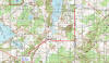
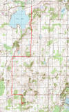
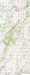
The drive begins at the intersection of Wisconsin Highway 23 and Sheboygan County A, in
the town of Greenbush. From WI 23, turn south onto County A. You'll soon find the Wade
House, which, when completed in 1853 by Sylvanus Wade, became the most important
stagecoach stop on the plank road running from Sheboygan to Fond du Lac. The historical
complex here includes a blacksmith shop where horses were shod and stages repaired, as
well as the Butternut House, home to Wade's eldest daughter and son-in-law. |
| |
|
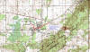 |
At the stop sign with the Wade House on the right, turn right onto
Plank Rd. One block later, turn
left onto Center St, and then right after 2 blocks onto Washington St. After
visiting the Wade House (note: the Wade House tours and visitors center is usually not open until
mid-June) traveling East on Washington St. a short distance, turn right
onto County T, after traveling approximately 6 tenth's of a mile bear
left onto Kettle Moraine Dr.
following the Kettle Moraine Scenic Drive signs. The road here is winding and narrow, and
the trees close in on either side as you bump over the moraine. You'll pass the Greenbush
Recreation Area and Greenbush Picnic Area (great spots for hiking and mountain biking)
before you come to the second stop on this tour, Greenbush Kettle. |
| |
|
 |
The parking area for Greenbush Kettle is on the left, just past a sign that says
"Shelter 5." Park and walk back along the entrance road to a trail and a wooden
stairway leading down into a big hole in the earth—Greenbush Kettle. Standing at the
lip of the kettle, imagine being here ten thousand years ago, at the end of the Ice Age.
The glacier has mostly retreated to north of here, and there is no hole before you, just a
treeless space covered with sand and boulders. Beneath the sand at this spot is a huge
piece of ice left behind in the glacier's retreat. As time passed, the ice melted and the
land dropped, finally leaving this depression. You can best appreciate the immensity of
the stranded ice chunk from the bottom of the stairs. |
| |
|
 |
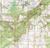
Just past Greenbush Kettle, the road forks. Follow Kettle Moraine Scenic Drive to the
right. At the stop sign and junction with Wisconsin Highway 67, turn left onto WI 67.
Travel approximately 0.5 mile to County A and turn right. The mixed pine and hardwood
forest here is dense, and the road rolls up and down through the moraine. At the junction
with Sheboygan County U, turn right and travel approximately 0.25 mile to the parking area
for Parnell Tower, a 50-foot observation tower built atop a high ridge of the moraine. The
tower is about an eighth of a mile up the trail leading from the parking lot. The view
from the tower is well worth the climb. To the west, in the distance, you'll see a series
of bumps that rise above the relatively flat land around them. These are drumlins, glacial
debris composed mainly of silt and clay with some small pebbles. The long axis of the
drumlin is arranged in the direction of the ice's forward movement, roughly north-south
here. |
| |
|
 |
Turn right onto County U out of the Parnell Tower parking area, travel just over 1 mile
and turn left onto Woodside Road/Kettle Moraine Drive. After traveling 0.25 mile, turn
left onto Shamrock Road; go 1 mile further and turn left onto the Scenic Drive. At the
next stop sign you come to, turn right onto Sheboygan County V (though the road isn't
marked at the intersection), and then after a short distance on County V, turn
left
(following the Kettle Moraine Scenic Drive sign) onto Butler Lake Road. The long sinuous
ridge on the left side of the road is the Parnell Esker, one of the longer eskers in the
state forest. Eskers mark the path of meltwater streams that flowed underneath the ice and
consist of the glacial sediment deposited along the bed of the sub-glacial stream. |
| |
|
| |
At the stop sign, turn left onto Division Rd, and at the next stop sign and the junction with Sheboygan
County F, turn right. At the next stop sign and the intersection with WI 67 in downtown
Dundee, go forward, following WI 67 south. Dundee is home to the world-famous (among
geology buffs, anyway) Dundee Kame, known locally as Dundee Mountain, a 250-foot pile of
sand, pebbles, and boulders that formed at the bottom of a hole in the retreating glacier.
Glacial meltwater streams running along the glacier's surface washed the debris into the
hole, and the debris accumulated at the bottom of the hole. The perimeter of the base of
the Kame will give you an idea of the size of the hole in the ice. |
| |
|
 |
For a good view of Dundee Kame and more glacial geology, head for the Henry S. Reuss
Ice Age Visitor Center up a hill just outside of Dundee on WI 67. As you're headed up the
hill, you'll notice that the Kettle Moraine Scenic Drive veers off to the left on
Sheboygan County G. If you want to skip the interpretive center, follow it left here.
Otherwise, continue up the hill to the top and turn left into the center's driveway. The
center features a large mural depicting the surrounding area roughly ten to twelve
thousand years ago, at the time of the glacier's final retreat. The center shows a twenty
minute film, and signs outside the center interpret several glacial features visible
nearby. |
| |
|
 |
When you leave the center, turn right onto WI 67 and then right again onto County G and
the Kettle Moraine Scenic Drive route. After rolling through the forest a bit, the road
drops down to run alongside a glacial outwash terrace. A restored prairie now covers the
outwash terrace. The terrace formed when sand and gravel were washed by meltwater streams
from the retreating glacier's surface and deposited here, forming this broad, flat plain.
At the intersection with Sheboygan County SS, turn left and cross the outwash terrace.
There is a wildlife viewing area on the left side of the road not far from the
intersection. When you've crossed to the other side of the terrace, turn right onto
Sheboygan County GGG. |
| |
|
 |
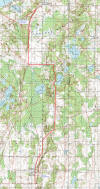
This paragraph is devoted entirely to directions to get you through an
extremely poorly marked section of this route. Stay sharp. Here goes. When
County GGG meets Sheboygan County S, turn right, and at the stop sign in New
Fane, turn left onto Kettle Moraine Dr. After going forward through a couple of
intersections, turn right at the T-intersection with Ridge Rd. (which was
completely devoid of signs or markings when I was here). After a brief segment
of Ridge Rd. a curve to the left becomes Kettle Moraine Dr. again. At the next
stop sign at Newark Rd and Lighthouse Lane, turn right onto Lighthouse Lane and
cross the Milwaukee River. At the stop sign across the river, go
forward, and at the stop sign and intersection with County Highway D,
turn right onto County Highway D westbound. After passing under Highway
45, you’ll go up a big hill, and at the top of the hill when Highway D
banks right, turn left onto Kettle View Dr. Go forward at the next stop
sign, and at the stop sign after that turn right onto Shuster Dr. If all
is well, the next intersection you come to should be Glacier Drive,
where you turn left. |
| |
|
 |
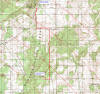
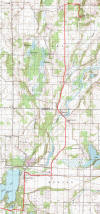
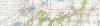
At the intersection with Wisconsin Highways 33 and 144. Follow WI 144 south.
You have now left the North Unit of the Kettle Moraine State Forest. WI 144 runs along the
top of the moraine, with wooded hills all around. At the stop sign in the town of Slinger,
go forward. Turn right at the junction with Wisconsin Highway 60 onto WI 60 west
(West Commerce Boulevard), and
after approximately 2 miles turn left into Pike Lake State Park on Kettle Moraine Road.
Pike Lake State Park has twenty-five well-spaced campsites, as well as hiking, biking,
fishing, and swimming. The park office is on the left at the WI 60/Kettle Moraine Drive
intersection, and Pike Lake is just over the hill on the right. |
| |
|
 |
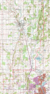
Continue on Kettle Moraine Drive past the intersection with Washington County E, and at
the intersection with Waterford Road, turn right. At the junction with Washington County
K, turn left. On your left, just after you turn onto County K, is Holy Hill (a kame,
actually), the highest point in the Kettle Moraine and the site of a Catholic monastery.
An observation deck at the top of the hill provides spectacular views of the surrounding
countryside. To get to Holy Hill, turn left onto WI 167 and follow it up the hill.
Otherwise, keep headed south on County K, which, when it reaches the county line, changes
(in name only) to Waukesha County E. |
| |
|
 |
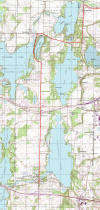
The next town you come to is Moonches, named for an Indian chief who lived near here.
Just after Moonches, County E turns right at a stop sign. Follow it, and then at the
intersection with Waukesha County VV, turn right. In the town of North Lake, turn left
onto Wisconsin Highway 83 at the stop sign. At the intersection with Waukesha County K,
turn right onto County K. After a few miles, turn left onto Waukesha County C. You'll
cross over Wisconsin Highway 16 at Neshota, one of the far outposts of the Milwaukee metro
area. Continue on County C to Delafield, home of the Fox Inn, once an important stopping
point on the stagecoach route that ran between Madison and Milwaukee. In Delafield, turn
right onto Wells Street/County C, and you'll see the Fox Inn from the road. |
| |
 |
| |
|
 |
Outside of Delafield, County C crosses I-94, and on the left after you cross the
interstate is Lapham Peak, birthplace of the National Weather Service. Increase A. Lapham,
a conservationist and scientist who lived here in the 1800s (also winner of the Goofy Name
Award and the peak's namesake), worked with the U.S. Army Signal Corps to set up a series
of signal stations between Pike's Peak in Colorado and Lapham Peak to transmit weather
data from west to east. Blue Mound State Park (Drive 19) west of Madison was the site of
one of the stations. The meteorological data was transmitted to Lapham's office in
Chicago, and Lapham then warned Great Lakes ports of impending storms. The view
from the peak is excellent, showing sixteen of the surrounding lakes. |
| |
|
 |
At the stop sign after Lapham Peak, follow County C to the right. After approximately 1
mile, follow County C when it turns left. At the intersection with Waukesha County G,
you'll cross what was once an important Indian trail running from Lake Koshkonong (west of
Whitewater) to Milwaukee. Don't worry if you don't actually see the trail; it's not
marked. Turn right here and follow County C. At the intersection with Waukesha County D, cross County D and immediately turn left
onto Town G/Waterville Road. At the fork in the road and the sign for County GG, bear
right. At the next intersection turn right onto County ZZ, to enter the South Unit of the Kettle Moraine
State Forest. At the junction with WI 67, turn left onto WI 67, and in a few miles you
come to Eagle, where the first diamond found in Wisconsin was discovered in 1876. Eagle is
also home to Old World Wisconsin, a collection of more than 50 historic farmhouses, barns,
and merchant shops on 600 acres of wooded hills. If you'd like to see it, follow WI 67
approximately 3 miles south of town. If not, take Wisconsin Highway 59, the right-most
road at the funky six-way intersection in Eagle.
|
| |
|
| |
|
 |
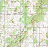
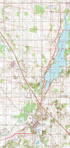
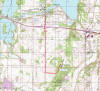
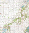
In Palmyra, approximately 6 miles out of Eagle, go forward onto Jefferson County H
where WI 59 turns right. On your right, a short way down County H, you'll see cropland in
a shallow valley. The land surrounding the valley is a glacial outwash plain, created when
fine glacial particles were washed out of the glacier by running water. The valley itself
is called a spillway, where a smaller meltwater stream cut through the already-deposited
sandy plain. Turn right onto Kettle Moraine Drive, cross the spillway, and roll through
the outwash plain. The wooded ridge on your right is the moraine you've been following
this whole drive. On the left side of the road you can see (provided the corn isn't too
high) the Elkhorn Recessional Moraine in the far distance. The glacier's progress, both
advancing and retreating, was erratic; in the major advance of the last wave of glaciation
from twenty-five thousand to fifteen thousand years ago, there were many retreats. This
moraine marks the spot of a significant pause in the final retreat of the Lake Michigan
Lobe of the glacier. |
| |
|
 |
Go forward at the next stop sign, and the stop sign after that, and you come to the
Whitewater Recreation Area, with sixty-four campsites, a picnic area, a beach, and a boat
landing. Drive 0.75 mile past the recreation area and turn right onto Clover Valley Road.
At the intersection with Engle Road a mile later, turn right and travel 0.2 mile to the
end of this drive, where there is a hand-dug artesian well that has been flowing steadily
since 1895. The water is clear, clean, cold, and extremely refreshing for weary travelers
on a hot day. |
| |
|
| |
To get back to civilization, travel back to Kettle Moraine Drive, turn right, and
follow it to Wisconsin Highway 89. A right onto WI 89 will take you to Whitewater and U.S.
Highway 12. |
|
 The Drive